
The Kansas-Nebraska Act of 1854
During the 1850s, the push to organize the Kansas and Nebraska Territories was inspired by the prospects of gold, a Transcontinental Railroad, and Western settlement. Many farmers coveted the land along the Kansas and Platte Rivers, believing that it would make profitable farms, and favored a rail route passing through Kansas. The problem of determining the railway’s route—whether it would pass through northern (free) or southern (slave) territory—was hotly debated and prevented construction for many months.
Senator Stephen Douglas, one of the railroad’s chief promoters, stepped in and argued that the rule of popular sovereignty that had effectively been implemented in the Compromise of 1850 should also apply to Kansas and Nebraska. The Compromise of 1850 organized the remaining portions of Mexican Cession into New Mexico Territory and Utah Territory under the concept of popular sovereignty, allowing the people of each territory to decide whether or not slavery would be permitted.
In May of 1854, the Kansas-Nebraska Act was passed by the 33rd United States Congress and signed into law by President Franklin Pierce. The Act ultimately repealed the long standing Missouri Compromise of 1820, and opened the area of the Louisiana Purchase Territory yet to become states to slavery.

This detail from Jacob Monk’s New Map of that Portion of North America, published in late 1854, right after the passing of the Kansas-Nebraska Act, shows the newly organized “Kanzas Territory” and “Territory of Nebraska.” Almost completely empty and beckoning new settlements, the most prominent details engraved in these new territories are the Platte River and Kansas River. LINK.
The Kansas-Nebraska Act gave Southerners two opportunities to create two slave states out of Kansas and Nebraska. While there was no debate over the issue in Nebraska, as the territory was filled with settlers from Minnesota and Iowa where there was no slavery, in Kansas, the situation was much different. Many Northerners and Southerners went to Kansas in 1854 and 1855, determined to convert the future state to their view on slavery. To ensure that their respective side would win, both Southerners and Northerners advocated the use of violence. This led to "Bleeding Kansas," a mini civil war that erupted in Kansas in 1856.
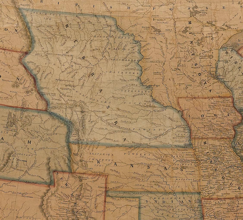
Published just three years after the Kansas-Nebraska act, the quick population boom and rapid settlements in Kansas and Nebraska territories are already visible in the engraved details of this scarce 1857 American wall Map of the United States by Ensign, Bridgman, and Fanning. Settlers flooded into the eastern parts of the territories from bordering states like Iowa, Missouri, and Arkansas, hoping to sway the debate of slavery to their side. LINK.
Each side drafted constitutions, but the anti-slave faction eventually gained the upper hand. Kansas was admitted to the Union as a free state on January 29th, 1861, about two-and-a-half months before the first shots of the Civil War were fired.

The star count on this 34-Star Great Star "Flower" Pattern Flag celebrates the admittance of Kansas to the Union as the 34th state. It was admitted as a "free state" on January 29th, 1861. LINK.
