

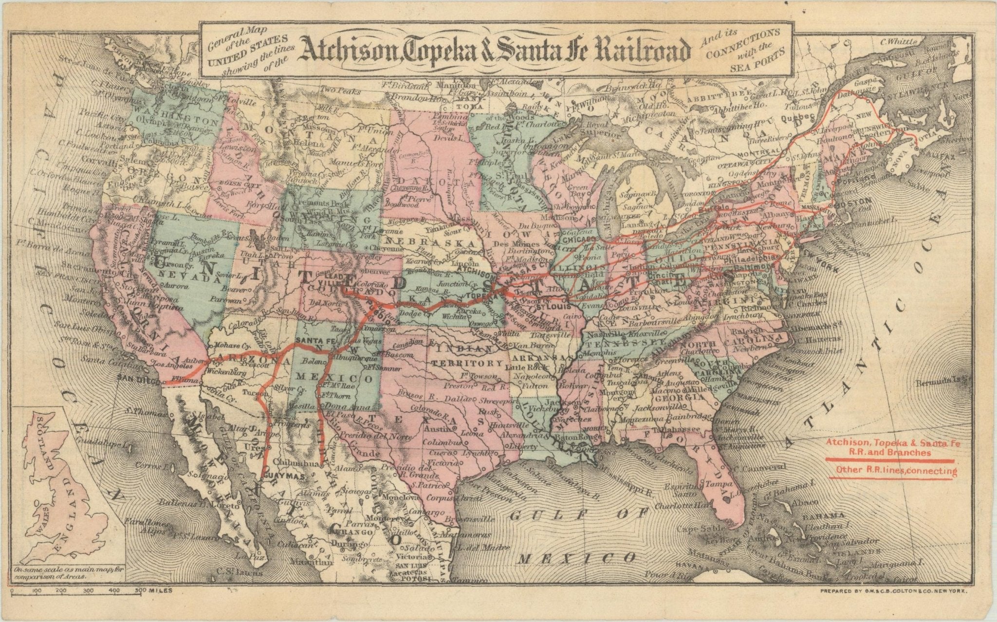

"General Map of the United States Showing the Lines of the Atchison, Topeka & Santa Fe Railroad" by G. W. & C. B. Colton, circa 1879
Presented is an original "General Map of the United States Showing the Lines of the Atchison, Topeka & Santa Fe Railroad and Its Connections with the Sea Ports". Undated, this map was published in New York by G.W. & C.B. Colton, circa 1879. This small, folding map of the United States highlights various railroad routes of the Atchison, Topeka & Santa Fe Railroad in bright red, extending from east coast ports like Halifax, Boston, New York and Philadelphia to St. Louis, Chicago, and Atchison, Lead Valley and Pueblo in Colorado, extending into the Southwest with Santa Fe, San Diego, and ending in the Mexican cities of Guaymas and Chihuahua. It includes a small inset map of Britain at the bottom left, drawn to scale for sheer size comparison.
The verso of the map features three panels of German text titled "Amerika," marketing settlement to the rich agricultural lands of southwest Kansas owned by the railroad. One section of text states that “Kansas should be called ‘Mesopotamia’ because of its fertility, and its rivers, Kansas and Arkansas, the ‘Euphrates’ and ‘Tigris’, should indeed be called one of the pearls of North America, and whoever has once visited them must join in the general praise of Kansas' agricultural conditions." Another section boasts that “the Atchison, Topeka, and Santa Fe Railroad is the facilitator of a magnificent traffic route between the mining regions of the Rocky Mountains and the great breadbasket of the continent. It runs through the richest regions of Kansas and connects them with the silver and gold-producing mountains, where the products of Kansas farms find a profitable market.” The Santa Fe railroad actively and successfully promoted settlement in Kansas among German communities in Europe, with maps and pamphlets just like this one.
Founded in 1859, the Atchison, Topeka and Santa Fe Railway was created to connect the Kansas frontier town of Atchison with the growing trade routes of the American Southwest. But what began as a regional railroad soon became one of the largest and most influential railroads in the United States, stretching from the Midwest to the Pacific. The Santa Fe Railway forged paths into previously inaccessible regions, bringing infrastructure, settlers, and commerce to the American West. Unlike other railroads that primarily served established cities, the Santa Fe created new towns just by laying track across vast, unsettled land. It gave rise to dozens of communities and helped make states like New Mexico, Arizona, and California more accessible and economically viable.
The Santa Fe railway was a powerful engine of economic change- transporting cattle, minerals, lumber, and agricultural products from the West to markets in the East and Midwest. It played a critical role in the cattle boom of Texas and Oklahoma and helped turn the arid lands of the Southwest into productive agricultural hubs through irrigation efforts. The Santa Fe made it possible for small frontier settlements to connect with national markets. The resulting economic growth reshaped not only the Western states, but the national economy as a whole.
CONDITION:
Very good condition. Issued folding, with light creasing along fold lines as expected. Engraving with original handcoloring, in light water color wash of pink, green, yellow. With red overprinting, marking railroad routes. Small inset map of England, Scotland, and Wales at bottom left. Publisher’s line, “Prepared by G.W. & C.B. Colton & Co. New York,” printed at bottom right margin. Minor toning and small stain at top. Verso has three printed panels of German text, with pen inked inscription at bottom right “Philipp Behrene, aus Rodenberg, Station Haste Nendorft.” Map Dimensions: 5.2” H x 8.9” W.
Archivally framed, with acid-free dark mats, UV glass, and custom wooden frame with gold beaded spandrel.
Framed Dimensions: 9 3/4"H x 12 7/8"W x 5/8"D.
Accompanied by our company's letter of authenticity.
Pickup available at Colorado
Usually ready in 4 hours
"General Map of the United States Showing the Lines of the Atchison, Topeka & Santa Fe Railroad" by G. W. & C. B. Colton, circa 1879
Colorado
1 Lake Avenue
Colorado Springs CO 80906
United States
Choose options
Frequently Asked Questions
FAQs
Yes, all of our Antiques are certified authentic. Every antique comes with a signed Letter of Authenticity that details the item’s history, its current condition including any conservation, binding, or framing work, and the item’s provenance. The Letters of Authenticity are priced valuations by our authentication specialists, who assure that items are original and unconditionally guaranteed as genuine for life.
We pack and ship your items from our gallery in Colorado Springs. You may also choose to come pick up your order. Antique items are carefully packed and insured during shipping. The shipping price will be calculated at checkout.
We acquire from a variety of trusted sources all over the world, but mostly through auctions and private collections within the United States. All provenance information will be listed on the Letter of
Authenticity accompanying your purchase.