
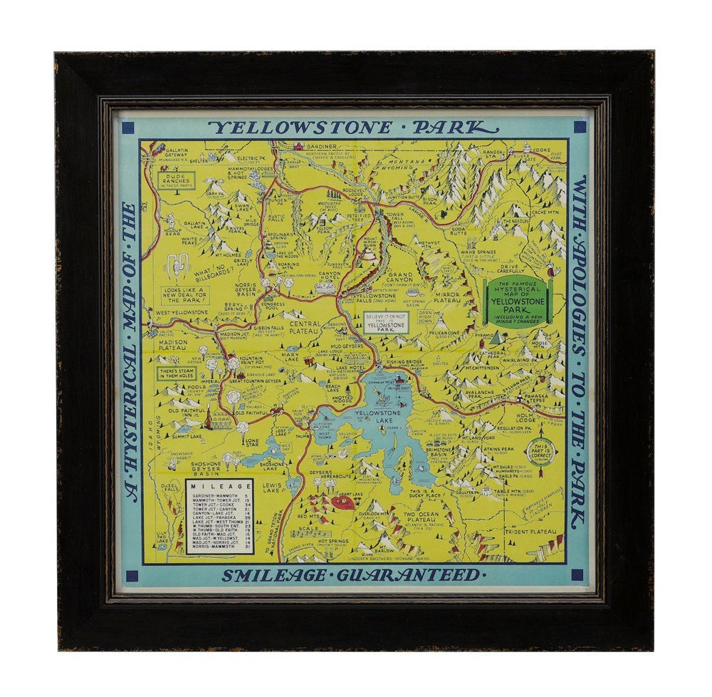


1948 "A Hysterical Map of Yellowstone National Park" by Jolly Lindgren, Second Edition Printing
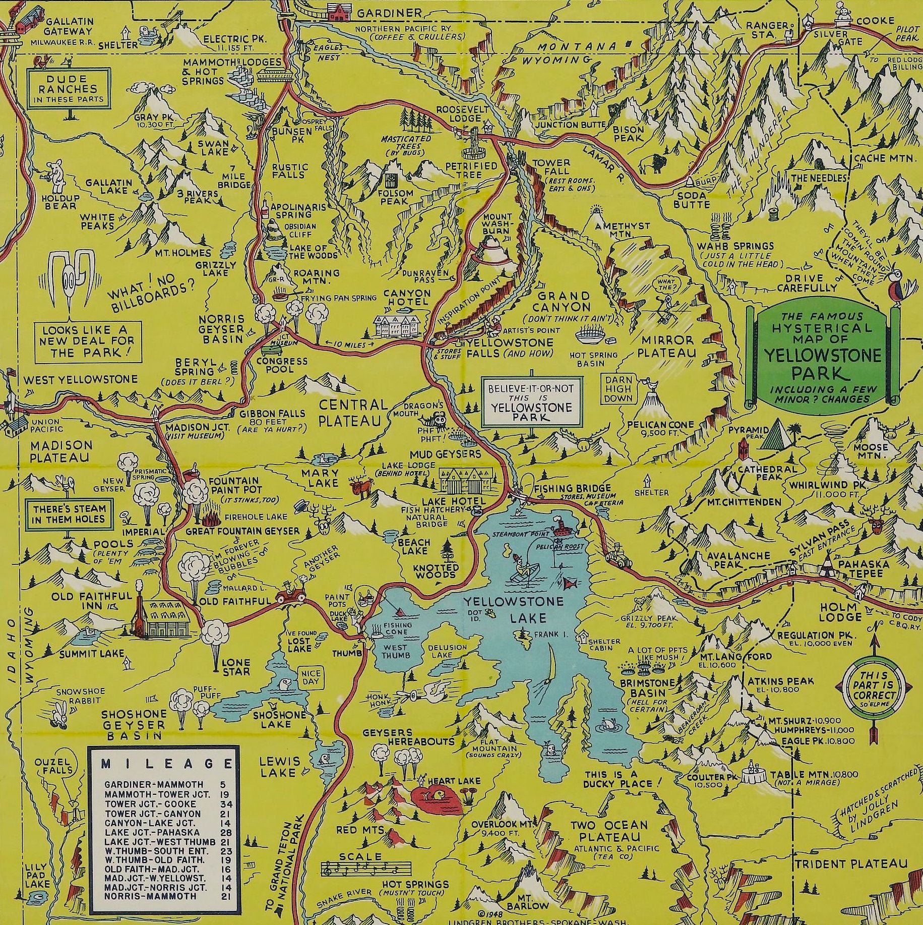
Presented is a second edition printing of Jolly Lindgren’s “Hysterical Map of Yellowstone National Park.” This comical pictorial map highlights the famous Yellowstone National Park. The map is labeled with geysers, mountains, lakes, and roads, but also filled with cartoonish figures, jokes, and puns. An inset chart at bottom left indicates mile distances from one popular mountain or junction to the next. First published in 1936, this second edition of the map was published by the Lingren Brothers in Spokane, WA, in 1948.
Lindgren maps have become well-known among collectors of 20th century maps for their distinctive style-- a yellow background, a blue border, and plenty of visual gags. Lingren maps blend historical facts and geographical data with tongue-in-cheek wordplay and cartoons. Labels like “Hot Springs- Mustn't Touch,” “Gibbon Falls- 80 Ft.- Are Ya Hurt?,” and “Grand Canyon- Don’t Think It Ain't!” offer playful commentary alongside real elevation data and helpful information for visitors like labels for ranger stations, distances between mountain ranges, and more.
Born Hjalmer and Oscar Lindgren to Swedish parents in Wisconsin in the 1890s, the brothers adopted the nicknames Jolly and Ott when they joined the Army during World War I. After returning from military service, Jolly Lindgren opened a commercial art studio in Spokane, Washington, where he made signs for local theaters. His older brother Ott joined him to help manage the business and Ted Turner, Jr. was brought on board to complete the business trio.
The Lindgren-Turner Company was founded in 1928. When the Great Depression hit, the company tried to stay afloat by making calendars, featuring a pictorial map of Spokane. “When it became clear that the map had more appeal than the calendar itself, the company shifted to mapmaking, taking advantage of the tourism industry and creating maps of national parks. Turner was the one who proposed using the word “hysterical” in the title, over “historical,” as historical maps were also common souvenirs” (J. Stoner, Library of Congress, 2020).
CONDITION:
Expert repairs to corners; touched-up at folds; light spotting in margin. Linen backed. B+/B. Map measures 16 x 16”.
Map has been expertly framed, to the highest archival standards in a custom-built wooden frame with acid-free mats and spacers. Framed Dimensions: 20”H x 20”W x 3/4”D.
Accompanied by our company's letter of authenticity.
Pickup available at Colorado
Usually ready in 4 hours
1948 "A Hysterical Map of Yellowstone National Park" by Jolly Lindgren, Second Edition Printing
Colorado
1 Lake Avenue
Colorado Springs CO 80906
United States
Choose options
Frequently Asked Questions
FAQs
Yes, all of our Antiques are certified authentic. Every antique comes with a signed Letter of Authenticity that details the item’s history, its current condition including any conservation, binding, or framing work, and the item’s provenance. The Letters of Authenticity are priced valuations by our authentication specialists, who assure that items are original and unconditionally guaranteed as genuine for life.
We pack and ship your items from our gallery in Colorado Springs. You may also choose to come pick up your order. Antique items are carefully packed and insured during shipping. The shipping price will be calculated at checkout.
We acquire from a variety of trusted sources all over the world, but mostly through auctions and private collections within the United States. All provenance information will be listed on the Letter of
Authenticity accompanying your purchase.