
1885 "Rail Road and Township Map of Wyoming" by George Cram
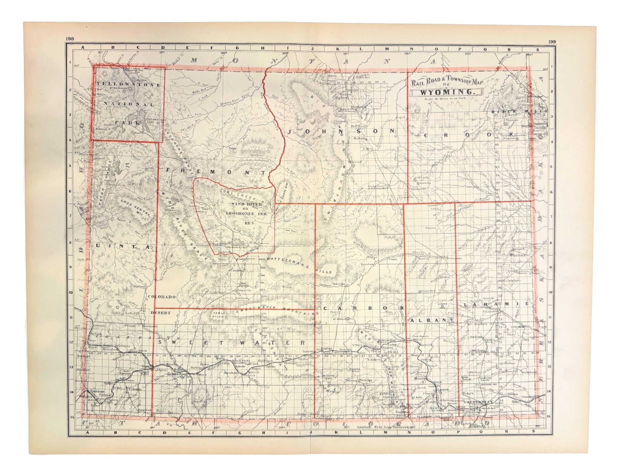
Presented is an original “Rail Road and Township Map of Wyoming” by George F. Cram, published in Grant's Banking and Business Atlas in 1885. A color lithograph with decorative red borders, the map presents the Wyoming Territory in remarkable detail, depicting mountain ranges, rivers, creeks, lakes, townships, county boundaries, and the expanding railroad network. Issued only four years before Wyoming achieved statehood in 1890, it captures the territory during a pivotal period of transition, when the railroad, mining, and ranching were rapidly reshaping the area.
The Wyoming Territory was established in 1868 from portions of the Dakota, Idaho, and Utah Territories. This map reflects the remarkable pace of settlement and development just seventeen years after it became a territory. The map records Wyoming when it was divided into only eight counties, following the creation of Fremont County in 1884. Large portions of the territory remained only lightly settled, particularly in the mountainous western and northern regions. Its settlement was concentrated primarily along the route of the Union Pacific Railroad. Snaking through southern Wyoming and completed in 1868, the Union Pacific Railroad transformed the territory. It linked it to eastern markets, encouraged immigration, and fostered the growth of towns like Cheyenne, Laramie, Rawlins, Green River, and Evanston. The line also facilitated the expansion of the cattle industry. Military posts including Fort Laramie, Fort Fetterman, and Fort Bridger are also prominently identified.
Also shown is Yellowstone National Park in the northwest corner, established by Congress in 1872 as the world's first national park. Set apart from county jurisdiction, Yellowstone represented a groundbreaking experiment in the federal preservation of natural landscapes.
The map documents the final decades of the territorial period, when Wyoming was evolving from a frontier region into an organized political entity. Mining communities flourished around deposits of coal, gold, and other minerals, while agriculture gradually expanded along river valleys. The territorial government, headquartered at Cheyenne, increasingly promoted permanent settlement and infrastructure improvements in anticipation of statehood.
George F. Cram (1842- 1928) was among the most influential American cartographers and publishers of the late nineteenth century. During the Civil War, he served under General William Sherman and participated in Sherman's infamous March to the Sea, leaving behind correspondence that has become a valuable resource for Civil War historians. In 1867, Cram entered the map publishing business with his uncle, Rufus Blanchard, in Evanston, Illinois. Two years later, he assumed sole ownership, establishing the George F. Cram Company. The firm became one of the nation's foremost producers of atlases and educational maps and was among the first American publishers to issue a comprehensive world atlas. Its celebrated Unrivaled Atlas of the World remained in continuous publication from the 1880s well into the mid-twentieth century.
CONDITION:
Near fine condition. Color lithograph. Light toning, specifically in margins. Vibrant red outlining. Center vertical fold line. Light ink smudges near margins in two places. Sold unframed, as-is.
Sheet Dimensions: 17 3/8” H x 22 3/4” W. Image Dimensions: 16” H x 19 3/4” W.
Accompanied by our company's letter of authenticity.
Pickup available at Colorado
Usually ready in 4 hours
1885 "Rail Road and Township Map of Wyoming" by George Cram
Colorado
1 Lake Avenue
Colorado Springs CO 80906
United States
Choose options
Frequently Asked Questions
FAQs
Yes, all of our Antiques are certified authentic. Every antique comes with a signed Letter of Authenticity that details the item’s history, its current condition including any conservation, binding, or framing work, and the item’s provenance. The Letters of Authenticity are priced valuations by our authentication specialists, who assure that items are original and unconditionally guaranteed as genuine for life.
We pack and ship your items from our gallery in Colorado Springs. You may also choose to come pick up your order. Antique items are carefully packed and insured during shipping. The shipping price will be calculated at checkout.
We acquire from a variety of trusted sources all over the world, but mostly through auctions and private collections within the United States. All provenance information will be listed on the Letter of
Authenticity accompanying your purchase.