1860 "Johnson's Nebraska and Kansas" Map by Johnson & Browning
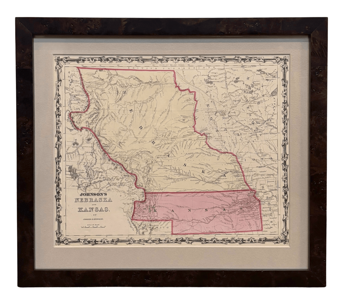
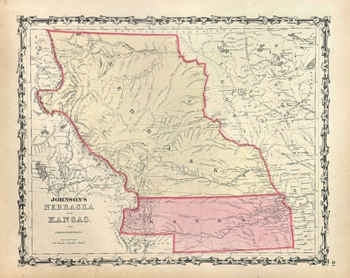
Presented is an original 1860 "Johnson's Nebraska and Kansas" map. This map was issued as page 51 in the “Johnson's New Illustrated (Steel Plate) Family Atlas” published by Johnson and Browning. The map is engraved, with attractive hand coloring and a decorative fleur de lis border. Kansas and Nebraska are both labeled, outlined in pink, and colored in pink and yellow. Partially depicted but not colored are the neighboring states and territories of Dakota, Minnesota, Iowa, Missouri, New Mexico, Utah, Oregon, and Washington. The map is beautifully detailed, with rivers and creeks, mountain ranges, and important forts and towns all marked.
This map captures the dynamic and rapidly changing geography of the central Great Plains just before the Civil War. Nebraska Territory, established by the Kansas-Nebraska Act of May 1854, is shown here stretching to British America. Encompassing the northern Great Plains and parts of the Rockies, it represented the northern frontier of organized U.S. territory. Within a year, its vast lands would be further divided with the 1861 creation of Colorado Territory (not yet shown on the map) and Dakota Territory (shown on the map).
Kansas Territory, also created in 1854, is shown extending westward to the Rocky Mountains, with borders far larger than the present-day state. Its boundaries and internal divisions would soon become infamous as the stage for “Bleeding Kansas,” a series of violent confrontations between pro-slavery and anti-slavery settlers that foreshadowed the coming Civil War.
At the time of this map’s printing, the area was still largely inhabited by Native American nations, whose territorial domains are carefully noted throughout. Several proposed routes for the transcontinental railroad are also shown, including the northern “Stevens Route,” the central “Beswith Route,” and the southern “Gunnison Route.” These proposed lines highlight the national desire to link the east and midwest with the Pacific Coast, a dream not realized until the completion of the Union Pacific in 1869.
“Johnson's New Illustrated (Steel Plate) Family Atlas” was first published in 1860 in New York and Richmond by Johnson and Browning. A huge publishing success and the company’s first major work, the atlas was then updated and re-issued over several years and under a handful of publisher iterations. In 1861, the Johnson & Browning firm left their Richmond location due to the outbreak of the Civil War. Browning remained in Virginia to pursue other ventures and, later that year, his portion of the firm was purchased by Ward. The 1862 and 1863 issues of the "Family Atlas" were thus compilations of both older Johnson and Browning maps and updated 1862 Johnson and Ward maps, which changed again in 1863 with new borders designs. The 1864 issue of the "Family Atlas" is the first true Johnson and Ward atlas. Johnson published one more edition in partnership with Ward in 1865, after which Johnson became the sole publisher of the "Atlas."
CONDITION:
Fine condition overall. Engraved, with original hand coloring. Page 51 from "Johnson's New Illustrated (Steel Plate) Family Atlas." Fleur de lis border. Colored in Kansas and Nebraska, uncolored for bordering states and territories. Light toning to paper. Small foxing spots.
Archivally framed with acid-free mats, UV Conservation Clear glass, and a custom built wooden frame.
Framed Dimensions: 17 1/2" H x 20 1/4" W x 1" D.
Accompanied by our company's letter of authenticity.
Pickup currently unavailable at Colorado
1860 "Johnson's Nebraska and Kansas" Map by Johnson & Browning
Colorado
1 Lake Avenue
Colorado Springs CO 80906
United States
Choose options
Frequently Asked Questions
FAQs
Yes, all of our Antiques are certified authentic. Every antique comes with a signed Letter of Authenticity that details the item’s history, its current condition including any conservation, binding, or framing work, and the item’s provenance. The Letters of Authenticity are priced valuations by our authentication specialists, who assure that items are original and unconditionally guaranteed as genuine for life.
We pack and ship your items from our gallery in Colorado Springs. You may also choose to come pick up your order. Antique items are carefully packed and insured during shipping. The shipping price will be calculated at checkout.
We acquire from a variety of trusted sources all over the world, but mostly through auctions and private collections within the United States. All provenance information will be listed on the Letter of
Authenticity accompanying your purchase.