
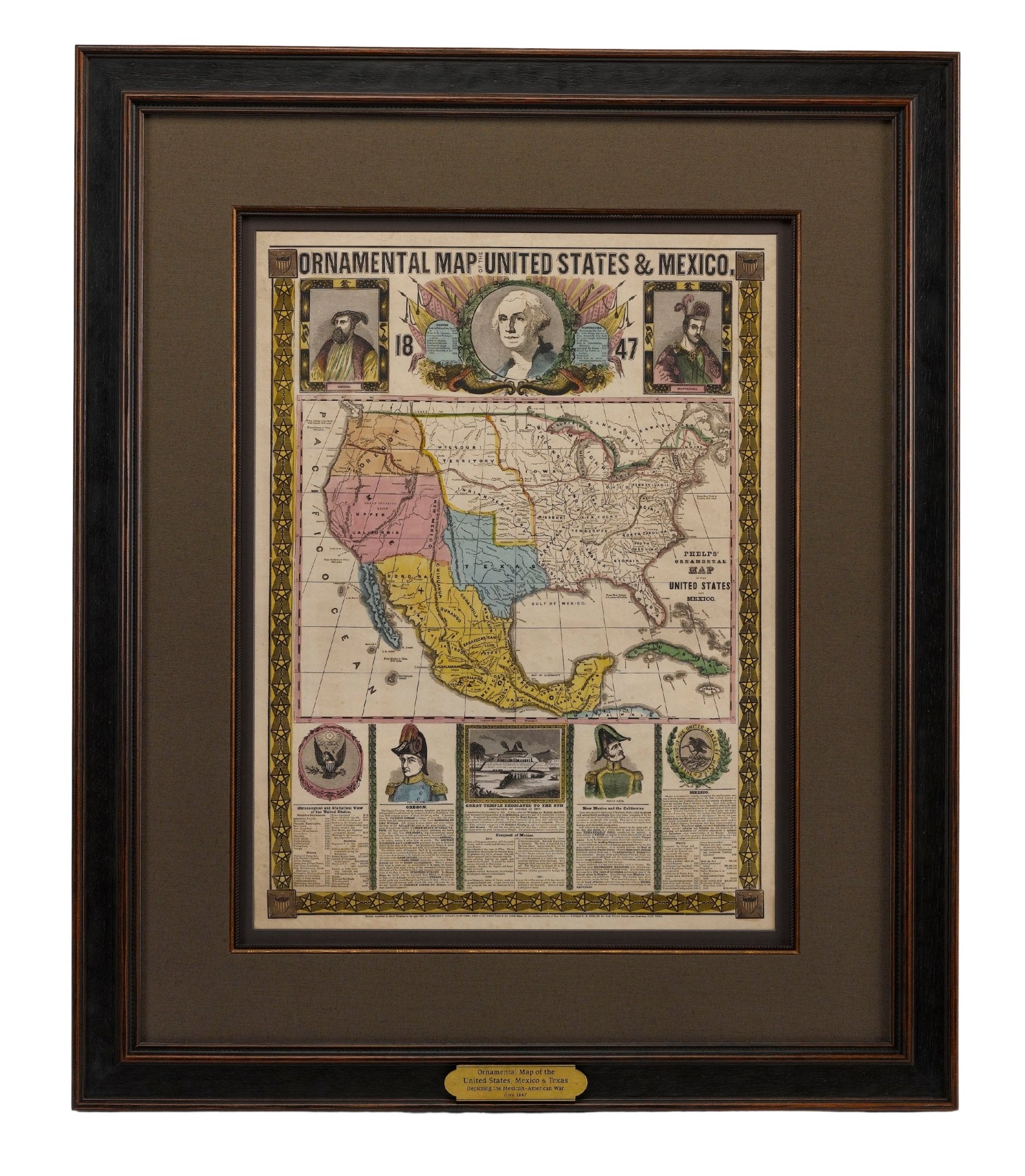
1877 "General Geological Map of Colorado"
New to our shop is this 1877 "General Geological Map of Colorado" by F. V. Hayden. The map was printed as part of the 1877 “Geological and Geographical Atlas of Colorado and Portions of Adjacent Territory,” lithographed by Julies Bein, and sponsored by the U.S. Department of the Interior.
-
Ferdinand Hayden was born in Westfield, Massachusetts in 1829. As a young boy he was fascinated with all nature and wildlife, which led him into the field of medicine. In Albany, NY, he worked under Professor James Hall, of the Geological Survey of New York. He graduated from Oberlin College in 1850 and from the Albany Medical College in 1853, after which Hall sent him on his first geological venture in the summer of 1853. During the Civil War, he rose to be chief medical officer of the Army of the Shenandoah and received a brevet to lieutenant colonel. After the Civil War he led geographic and geologic surveys of the Nebraska and Western Territories for the United States Government.
--
In 1869, Hayden led an expedition along the Front Range to Denver and Santa Fe. In 1870 he received a $25,000 governmental grant to lead a 20-man expedition to South Pass, Fort Bridger, Henry's Fork, and back to Cheyenne. To measure distances, Hayden employed the use of an odometer: a device used by mappers to estimate distances traveled. The device was mounted on a mule-drawn cart that measured distances as the cart wheels rolled along. Because of rough terrain, the device was accurate within about 3%.
-
In 1871, Hayden led America's first federally funded geological survey into the Yellowstone region of northwestern Wyoming, given directions by President Ulysses S. Grant's Secretary of Interior Columbus Delano. The survey consisted of some 50 men which included notables such as painter Thomas Moran and famous frontier/Civil War photographer William Henry Jackson. From his twelve years of labor and annual survey journeys there resulted a most valuable series of volumes in all branches of natural history and economic science. In 1877 he issued his Geological and Geographical Atlas of Colorado. The last of the annual survey journeys was in 1878.
-
As a result of Hayden's extensive geological work, he uncovered numerous dinosaur fossils, which he brought back east with him for further scientific study. Much of what he brought back is still housed in the collection of the Smithsonian Institution.

--
This 1877 Geological Map covers the following periods:
- The Quaternary Period - The third and last of the three periods of the Cenozoic Era. You and I are living in this period, which began only 2.58 million years ago. Quaternary rocks and sediments, being the most recently laid geologic strata, can be found at or near the surface of the Earth in valleys and on plains, seashores, and even the seafloor.
- The Tertiary Period - Began about 66 million years ago with a mass extinction that 'clocked' the dinosaurs and ended when the ice ages of the Quaternary Period began. Tertiary rocks are another name for metamorphic rocks. Ex: phyllite, schist, gneiss, quartzite and marble.
- The Cretaceous Period - An geological period that lasted from about 145 to 66 million years ago. These rocks are mainly sandstone and siltstone with subordinate amounts of conglomerate, shale, mudstone, and porcellanite. The rocks were deposited mainly in shallow seas and reflect several marine transgressions and regressions. They have a cumulative thickness of almost 13,000 feet.
- Jura-Trias Period- A geologic period and stratigraphic system that spanned from the end of the Triassic Period 201.4 million years ago. Rock consisted of boulders and smaller fragments of Carboniferous Limestone, and less commonly Portishead Formation sandstone, bound together with finer-grained sediment. The rock was deposited in steep-sided desert canyons called wadis, and on steep mountain slopes.
- The Carboniferous Period - lasted from about 359.2 to 299 million years ago during the late Paleozoic Era. The term "Carboniferous" comes from England, in reference to the rich deposits of coal that occur there. These deposits of coal occur throughout northern Europe, Asia, and midwestern and eastern North America.
- The Silurian Period - occurred from 443.8 million to 419.2 million years ago. Rocks are of marine origin and are composed of dolomite and shale and minor amounts of limestone and chert, with a total thickness ranging from 0 to 300 ft.
- Metamorphic Rocks - estimated to be as old as 3.8 billion years. Rocks form when they are subjected to high heat, high pressure, hot mineral-rich fluids and found deep within the Earth or where tectonic plates meet. Often found in mountain ranges where high pressures squeezed the rocks together and they piled up to form ranges such as the Himalayas, Alps, and the Rocky Mountains.
- Eruptive Rock - Up to billions of years old and consist of rocks that form at erupting volcanoes and oozing fissures. The magma, called lava when molten rock erupts on the surface, cools and solidifies almost instantly when it is exposed to the relatively cool temperature of the atmosphere.


